


توضیحات Horizon Explorer AR
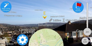
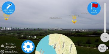
Point your camera at a landmark you can see on the horizon (eg. Hill, Mountain, Road, Lake, Building) and see:
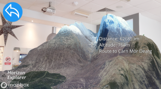
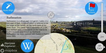
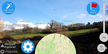
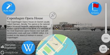
- Name of the landmark
- Distance from you
- Altitude (& relative to you)
- Map of surrounding area
- Nearby towns and cities
- Wikipedia info for any landmark with a Wikipedia page
- Direction from you (eg. Northwest)
- Directions to landmark (opens in google maps)
- Street view for where you're pointing (opens in google maps)
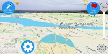
Or use 3D Map mode:
- See terrain laid out in front of you
- Move phone to fly around the map
- Roadmap / satellite / hybrid
- Search & display 3D-maps for anywhere worldwide
- Distance, altitude and landmark names
- Infinite scroll
Horizon Explorer works worldwide, but works best on top of a hill with an unobstructed view of your surroundings. You can drag the horizon line with your finger to line up with the camera if the automatic tracking is not working very well. Or try waving your phone around in the air in a figure 8, then pressing "align using compass" to calibrate the compass.
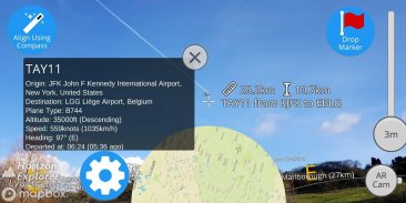
Live airplanes can also be enabled, starting from $0.99. Point at a plane and see the flight number, origin, destination, altitude and current airspeed of any commercial airline plane you can see.
If you are in a tall building, or otherwise not standing on the ground, enable "Tall Building mode" and optionally set your altitude using the slider.
Horizon Explorer will show mountain names, lakes or forests, the names & designations of roads, and many buildings.
Wikipedia Information will be displayed for anything that has an English Wikipedia article with a location set.
This app uses Google's ARCore to do augmented reality. This technology is currently available on ~50 phones: https://developers.google.com/ar/discover/supported-devices
If you don't already have the latest ARCore app installed, you will be prompted to install / update it from the Play Store when you first open Horizon Explorer.
دوربین خود را در نقطه عطفی که می توانید در افق ببینید (مانند هیل، کوه، جاده، دریاچه، ساختمان) را مشاهده کنید و ببینید:
- نام برجسته
- فاصله از شما
- ارتفاع (و نسبت به شما)
- نقشه منطقه اطراف
- شهرهای و شهرهای نزدیک
- اطلاعات ویکیپدیا برای هر علامت با یک صفحه ویکیپدیا
- جهت از شما (به عنوان مثال، شمال غربی)
- جهت به نقطه عطف (در نقشه های گوگل باز می شود)
- نمای خیابان برای جایی که به آن اشاره می کنید (در نقشه های گوگل باز می شود)
یا از حالت نقشه 3D استفاده کنید:
- زمین را که در مقابل شما قرار دارد را ببینید
- حرکت تلفن به پرواز در اطراف نقشه
- نقشه راه / ماهواره / هیبرید
- جستجو و نمایش 3D نقشه برای هر نقطه در سراسر جهان
- فاصله، ارتفاع و نام های برجسته
- اسکرول بی نهایت
Horizon Explorer در سراسر جهان کار می کند، اما در بالای تپه با منظره ای غیر مستقیم از محیط اطراف کار می کند. شما می توانید خط افق را با انگشت خود بکشید تا در صورت ردیابی خودکار به خوبی کار کند. یا امتحان کنید تلفن خود را در هوا در شکل 8 قرار دهید، سپس دکمه "تراز کردن با استفاده از قطب نما" را برای کالیبراسیون قطب نما.
هواپیما های زنده نیز می توانند از $ 0.99 فعال شوند. نقطه در یک هواپیما و شماره پرواز، مبدا، مقصد، ارتفاع و سرعت هوایی فعلی هر هواپیمای تجاری تجاری که می توانید ببینید را مشاهده کنید.
اگر شما در یک ساختمان بلند هستید یا در غیر این صورت بر روی زمین ایستاده اید، حالت Tall Building را فعال کرده و ارتفاع خود را با استفاده از نوار لغزنده تنظیم کنید.
Horizon Explorer نام کوه ها، دریاچه ها یا جنگل ها، اسامی و نامگذاری جاده ها و بسیاری از ساختمان ها را نشان می دهد.
اطلاعات ویکی پدیا برای هر چیزی که یک مقاله ویکی پدیا انگلیسی دارد با مجموعه مکان نمایش داده میشود.
این برنامه از ARCore گوگل برای انجام واقعیت افزوده استفاده می کند. این تکنولوژی در حال حاضر در حدود 50 تلفن در دسترس است: https://developers.google.com/ar/discover/supported-devices
اگر شما قبلا برنامه ARCore جدید را نصب نکرده اید، از اولین بار که برای اولین بار Horizon Explorer باز می شود، از آپدیت / آپدیت آن از فروشگاه Play درخواست می شود.
Horizon Explorer AR - نسخه 1.23.0
(23-04-2020)Horizon Explorer AR - اطلاعات APK
نسخه APK: 1.23.0حزمة: com.arrowsd.horizonexplorerاپلیکیشنها در دسته مشابه
شاید دوست داشته باشید...


